news hardware Google has a different mapping system than Maps and you don’t know about it
Dynamic World is a powerful satellite imagery tool that Google reserved for scientists and professionals. It shows the condition of soils around the world with an accuracy of 10 meters.
On the other hand, if Google Maps is a mapping system that serves all travelers around the world, Dynamic World has it a completely different goal. This tool was developed by the Mountain View company provides a real-time display of land use across the planet
Designed in collaboration with the WRI (World Resources Institute)Like Google Maps, Dynamic World is based on the Google Earth engine. In addition a powerful machine learning technology, AI Platformwhich is responsible for cross-checking information provided daily by a satellite to project land use on a map with an accuracy of the order of 10 meters.
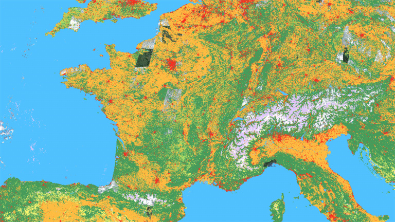
A nice view of Europe.

What is Dynamic World for?
in the a blog post released on June 9th and named “Land cover data is now real-time”Tanya Birch, senior program manager at Google Earth Outreach, explains that the tool fills a very specific need: to follow day by day the evolution of the earth’s land cover. “Our planet is changing dramatically in ways that are visible even from space”, she remarks. Whether we are talking about changes due to environmental disturbances or human activity, There is enough to change the landscape every day : fires, floods, deforestation, urban area development, etc.
“Detailed information about these changes and their impacts on people, climate and ecosystems can help governments and researchers design useful solutions and minimize their impact on issues such as climate change, food insecurity and biodiversity loss »adds the engineer.
From August to September 2021, Dynamic World will depict the devastation of the California fires.
And this is where Dynamic World comes in: processing the information gathered by this platform’s artificial intelligence allows the land cover map to be updated “almost in real time” and on a global scale.
An astronomical amount of data
While the vast majority of cartographic solutions are content to assign a single type of ground event to a specific area – for example a forest, a city, fields or even snow. Dynamic World can display several of them. The teams working on the tool have identified themselves nine “critical” land cover types : Water, flooded vegetation, built up areas, trees, crops, bare ground, grass, shrubs and snow/ice.
“Dynamic World uses AI and cloud computing to detect combinations of different land cover types and make inferences about the probability that each of the nine types is present in each pixel of a satellite image.”explains Tanja Birke. The result is therefore surgically precise.
These two Dynamic World images show the evolution of Taal Volcano and its surroundings after it erupted in January 2020 in the Philippines.
In order to achieve such a level of rendering and above all to be able to guarantee daily updates, Dynamic World’s artificial intelligence analyzes nearly 5,000 satellite photos provided by Copernicus Sentinel-2 every day. 5,000 photos a day might be a lot for an AI, but when you know thatOne pixel of each shot corresponds to more than 100m² of land on the ground, it still represents a lot of information to process. Currently, Google’s tool has a history dating back to June 2015 ” two days ago “.
A powerful tool for decision makers
“With this information, people – like scientists and policymakers – can monitor and understand land and ecosystems so they can make more accurate predictions and effective plans to protect our planet in the future.”appreciate Tanya Birch. We can hope that such a tool can help to effectively anticipate certain environmental problems.. What is certain for now is that Dynamic World is the privileged witness to the sometimes tragic changes that are taking place on the surface of the earth.
If you want to discover Dynamic World yourself, this is possible: One location provides access to ultra-precise, real-time ground mapping around the world. Good visit!


